
Upper Boggy Creek Integrated Watershed Management, City of Austin, Texas
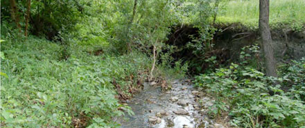
The City of Austin Watershed Protection and Development Review Department (WPDRD) identified Boggy Creek Reach 3 as a priority reach for stream rehabilitation and stormwater treatment work. The specific reach included the riparian corridor of Boggy Creek from Cherrywood Drive to 38½ Street. The total project length was approximately 1,500 lf. Typical problems in this area included channel instability, threatened water and wastewater pipelines, degraded stream habitat, and untreated road runoff. Reaches 4 and 5 were also named priority reaches for creek flood hazard mitigation. These two reaches are located along the main stem of Boggy Creek from 38½ Street on the northern or upstream end to MLK Boulevard on the southern or downstream end. In this location, approximately 65 homes are located in the floodplain with 36 homes and Manor Road bridge projected to be inundated in a 100-year flood event. The third reach included the floodplain of Boggy Creek from Rosewood Avenue to the upstream end of the Corps of Engineers’ concrete drop structure. Total project length was approximately 1,500 lf. Typical problems in this area included channel instability, abandoned wastewater pipelines, degraded stream habitats, and untreated stormwater runoff.